As anyone can well imagine, fulfilling a dream of becoming an adventure photographer is a road full of obstacles. In my case, the need for willing and able adventure buddies (read: subjects), the prohibitive cost of the necessary gear, and the limited extent of my outdoor adventure skills almost clouded my vision of that goal. Winter, in particular, scared me. You know, winter, the season most revered by extreme mountain enthusiasts.
This past spring, though, many of those clouds lifted and I caught a clear vision of my dream starting to take form. Thanks to the friends I made as a seasonal employee at Stowe Mountain Resort, I was offered chances to shoot backcountry skiers in incredible locations. In essence, I was being offered the chance to gain experience that I was unsure would ever come my way.
I participated in three backcountry shoots between March and May (Bruce Trail, King Ravine, and Mt. Jefferson), and all three resulted in those rare photographic gems I like to call “keepers.” Please read on for stories and photos from each event:
3/23 – Bruce Trail, Stowe, VT
I started modestly, riding a lift to the top of Stowe with a group of friends and taking a backcountry, but forgiving, route down to the XC center. The Bruce Trail — the first, but now abandoned, trail cut on the mountain — was the perfect candidate: narrow, fast, and filled with moguls and little jumps. I skied ahead of the pack, stopping and waiting at pitches that I felt would make for the most epic photos. We managed to squeeze in two runs before the lifts shut down, and I completely enjoyed the challenge of setting up on skis.

My favorite capture from the Bruce Trail shoot. It was a sunny day and contrast was very high, but I found I was able to save this shot by reducing contrast in the forest.
4/15 – King Ravine, Mt. Adams, NH
My next trip was a significant and awesome step up from lift-serviced backcountry terrain. This would be the trip that would test my endurance, tolerance for extreme terrain, and adeptness for catching photos at the perfect time. In one of my greatest triumphs to date, I began talking to our mountain dispatcher, a simply indefatigable adventurer named Aaron who has an insatiable appetite true backcountry skiing. Last year, he had skied King Ravine (whose headwall is imposing and nerve-rattling in the summer, mind you) for the first time and wanted to hit it again. He invited me along, claiming it would be a great start for my quests in adventure photography. He is not a liar.
We started this trip out on the evening on the 14th, tent camping near the base of the trail so that we could use the whole day for hiking into the ravine and skiing. We woke before sunrise on the 15th and headed back to the car to organize our gear for the day. We headed out about an hour after sunrise, Aaron gliding effortlessly up the grade on skis with skins, and me trudging up behind him on snowshoes. I chose not to bring skis on this trip due to gear restrictions, but I had Aaron’s patience so I was all set.

The morning commute.

Aaron nears the headwall. The Great Gully is the middle-most trail, to the right of the claw-shaped scar.
Once we arrived at the headwall, we stashed our unnecessary gear — Aaron’s skins, my snowshoes, etc — behind some brush that would protect it from a possible avalanche and secured our crampons on our boots. This is where the fun began.
From what I have read, King Ravine (whose slope reaches roughly 50 degrees near the top) is about as steep as any winter mountaineer would want to attempt without ropes. With that in our minds, crampons on our boots, and a mountaineering axes in our hands, we headed up the Great Gully. Unshaded from the sun, the climb was hot, slow, and tiring. The slope, probably about 20 degrees in the beginning, was steep enough to make normal hiking rather impossible. Instead, I had assumed a stab kick kick, stab kick kick pattern, placing just about all of my body’s pressure on the two front spikes of the crampons.

Heading up the lower section of the Great Gully.

Pausing for a breath on the upper section of the Great Gully.

Nearing the lip of the headwall, on a roughly 50-degree slope.
Halfway up, we stopped at the cliff dividing the Great Gully Trail from a gully containing a notorious ice bulge, and Aaron warned me to avoid that during my down climb. We also made plans for Aaron’s second run — he would climb into the Seven after his run, and if I made it down to this spot quickly enough I could shoot him skiing down from this spot. Wishful thinking, as it turned out.
Continuing up, we hit the steeper slope but stopped for shade only once. Eventually, we hit Thunderstorm Junction, marking the end of the headwall. The summit of Mt. Adams stood less than a mile in front of us, and Aaron made the impulsive decision to ski down from the very top, despite the spotty nature of the snowpack. I hiked up with him, scouting wind lips and good vistas on the way up, and then hiked down before him, waiting at a predetermined spot. I botched the shot of him leaping over the wind lip, but shook it off and met back up with him above the headwall. We put our packs back on and once again I headed down first to wait at a steep spot with a great view.

Skiing off the top of Mt. Adams.

The moment after Aaron landed the jump over the wind lip. Mt. Madison rises in the distance.

Carving the top of the Great Gully.

In the Great Gully.
This doesn’t need to be stated, but down climbing is not as fun as skiing when it comes to descending a mountain. I was facing uphill and picking my way down with a kick kick stab pattern. Flying down a mountain on a pair of skis may seem terrifying to the uninitiated, but it has nothing on the slow, burning, essentially-blind descent I was experiencing, all the while entrusting my life to a pair of metal teeth. I found a good spot, dug in, and waited maybe a minute for Aaron to come flying by. I caught the moment, took some extra shots to patch together into a panorama, and then packed the camera away and concentrated on the down climb. My heart was pounding — I knew that if I missed the trail to the right, or worse, slipped, I would find myself trapped on an ice bulge (or injured below it). I didn’t really want to find out just how trapped (or injured), so I descended slowly, kicking, stabbing, and kicking some more, and eventually found my path to the right. I noticed Aaron returning from his second run down below and knew that I had taken too long to get back to this spot.
Now on a friendlier slope and with the danger of the ice bulge gone, I relaxed and sped up my descent, even putting into practice the butt glissading that I had perfected during my time as a snowmaker. Back at our gear, Aaron and I agreed to rendezvous at the end of the ice caves, but after putting on the snowshoes and making my way down to the junction, Aaron wasn’t there. My first thought was that he went ahead without me, but that wasn’t his style so I scanned the area. I found him awkwardly balanced between boulders in the ice caves, holding skis and poles in one hand and trying to prevent himself from falling into the deep crevices with his other. Eventually back to safety, he explained that he missed the turn for the trail when skiing down from the gear stash, and had found himself at the top of the ice caves in snow that was too deep and too soft to climb out of. He had no option but to continue through the boulders, and admitted this was the most frightening aspect of the trip for him — the snow lying between the boulders obscured the caves’ true depths, and would not have supported him if he slipped off the rocks.
Aaron skied down the approach trail and arrived at the car within minutes, I’m sure, while I trailed hours behind him, fighting the sun-softened snow and “postholing” on just about every step of the way down, even in snowshoes.

A quasi-panorama I made from the upper half of the Great Gully.
5/1 – 5/3 – Cog Railway, Mt. Clay, Mt. Jefferson, and Jefferson Ravine, NH
While standing atop the summit of Mt. Adams two weeks prior to this trip, we were treated to an outstanding view of Jefferson Ravine and the significant snow fields therein, persisting into the spring. This, understandably, made Aaron restless, so here we were again, poised for another excursion into the White Mountains with skis on Aaron’s feet and snowshoes on mine. Now, however, we were parked on the opposite side of the of the Presidential Range, in the parking lot for the Cog Railway that leads to the top of Mt. Washington. Our plan for the three days in front of us consisted of hiking out to the Perch (an RMC-maintained lean-to) by way of the railway cut, Mt. Clay, and Mt. Jefferson, photographing Aaron skiing in the ravines for the following two days, and making it home healthy, happy, and in good form. Easy. Straight-forward. Bada-bing, bada-boom.
Roughly ten hours later, I stumbled into the opening for the Perch, lightheaded, slightly delusional, and with shoulders, neck, back, and legs all screaming in pain. I asked Aaron how far we had traveled that day, and he warned me that I wouldn’t want to know. He added up the mileage anyway, and shattered any sense of accomplishment that I had felt from arriving at our destination.
Our hike started out on the Cog Railway cut. Although it was the first day of May, snow still coated the ground down at the base of the mountain, so we put on our snowshoes or skis right from the start. We hiked up next to railway, whose every tenth crossbeam was numbered. This offered an odd distinction from all my other hikes — for better or for worse, our progress was easily measurable and often hard to ignore.
We worked our way uphill, the grade falling roughly in the middle of what I’ve encountered over my years of hiking. I fell behind Aaron, but not drastically so, as I felt my lack of sleep from the night before start to catch up to me. It wasn’t too long before we arrived at Jacob’s Ladder and a great view of Mt. Monroe. It was now that I realized conditions would be simply stunning for black and white photography — a fairly low cloud ceiling scraped the tops of the mountains while little spots of sun broke through, illuminating the mountaintops. I shot some photos and then decided I would be both safer and more efficient if I finished out the climb on the tracks themselves.

The view of Mt. Monroe from Jacob’s Ladder.

The Cog Railway from Jacob’s Ladder.

Another view from Jacob’s Ladder.

Aaron waits where we split off from the Cog to head to Mt. Clay.
The trek to Mt. Clay turned out to be the easiest walking of the day — we left the tracks as they veered towards the summit of Washington and walked a wide, gradually ascending plain towards our first summit of the day, standing only a few hundred feet above the col. Aaron started to peel further ahead of me as I approached this summit, due in part to our differences in gear (and level of fitness) but also to the call of my camera. Not only was I intrigued by the fantastic weather conditions against the dramatic scenery, I also wanted some space between my camera and my hiking partner to give the landscape some perspective.

Aaron heads towards Mt. Clay.

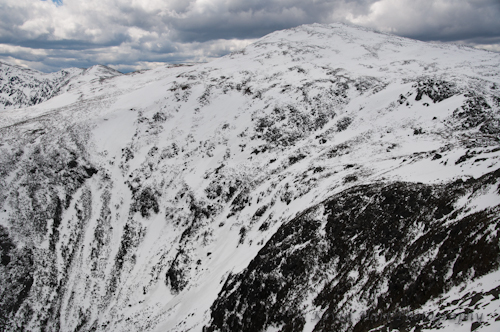
A panorama looking towards Mt. Jefferson.

Aaron’s tracks leading me over Mt. Clay.

I left the summit of Clay and plodded along in Aaron’s tracks, getting tired and hungry but promising myself that I would be on top of Jefferson soon and that I could break then. I had to keep moving — I was catching only glimpses of Aaron high on the mountainside above me.
This ascent up Mt. Jefferson turned out to be far demanding than I anticipated. Exhaustion was setting in as I coaxed myself up the peak, and I felt my upper back, shoulders, and neck begin to give way to very sharp pain. (My neck muscles, especially, have a history of sensitivity to backpacking.) Even my legs were starting to feel the pressure of the difficult ascent, fighting the steepness of the peak, the increasing deepness of the snow, and the tiredness from the long ascent up the Cog line. It felt like hours before I arrived at the spot where I had last seen Aaron, and I became aware that I was only halfway up the peak or less.
Eventually, after possibly the most taxing 700+ vertical feet I’ve ever climbed, I reached the summit of Mt. Jefferson in failing light. Aaron was nowhere to be found and he hadn’t left me with explicit directions to the Perch, so I looked around quickly (“this seems like a nice summit”), identified what had to be his tracks (turns out this was his intention — he went ahead with the specific purpose of leaving tracks to the Perch while there was still light), and headed down immediately (“screw eating, it’s late”). Aaron appeared to have some fun on his descent, but, choosing to prioritize not getting lost, I stuck to his tracks. On one particularly steep snowfield, during the last of the descent into Edmands Col, I lost my balance, fell over, and felt the weight of my pack drag me down the slope. I was able to self-arrest with a pole, and made it into the Col with everything but the pole in tact, and found a message in the snow reading “KEVIN, THIS WAY TO THE PERCH ——->”.
I ate a quick snack in the Col and continued on with the last of my hike. About a third of the way across the lip of Castle Ravine, I found Aaron, skinning his way back up from the Perch to check on my progress and well-being (he had turned around as soon as he had arrived at the Perch and was very relieved to find me past Jefferson). We had a view of the sunset as we trekked across the top of the ravine, and then hiked halfway down Israel Ridge by headlamp. Eventually, I stumbled into the Perch.
I had walked only five and a half miles.

The setting sun illuminates Castle Ridge as I made my way across Castle Ravine.
Now, of course, it was time to reflect on why, exactly, it had taken me over 10 hours to walk 5.5 miles. In the summer, a 5.5 mile loop up a mountain and back would take me no longer than 3 hours, unless I was waiting for light conditions to change. I was moving at less than a third my average pace. The following is a list of possible explanations for my snail’s pace, and inherent lessons for future winter travel:
- Travel on snow is always slower, and walking on snowshoes is naturally more awkward. The most efficient form of winter travel is skinning on skis (though I haven’t yet tested that theory).
- I was low on sleep — early and proper preparation is key for any outdoor adventure.
- I had an overnight pack on, which slows my pace even in summer. Consistent training is necessary to condition my body to heavy loads.
- Due to the added difficulty of moving on snow and the body’s need to produce more heat, higher caloric intake is necessary during the winter. I was holding off on snack breaks to compensate for my slower pace, resulting in undernourishment.
The following morning, sensitive to my body’s reaction to the previous day’s activities, Aaron suggested that we keep today’s activities a little more low-key than we originally planned. We got a slow start to the morning, a bummer to my photographic sensibilities but a huge relief to my aching but functioning body. Some rest, food, and Ibuprofen tablets later, I was ready for the (unexpectedly easy) trek back up to the ridge.
We scouted out an acceptable vantage point of Jefferson Ravine, a rocky outcropping with a pretty fantastic view of the Presidential Range stretching from Washington to Madison. The entirety of Jefferson Ravine lay in plain view below me. Aaron left me here and skinned to the top of Jefferson’s summit, providing me with a view of his runs both down the snowfields of the peak and the steep, narrow chutes of the ravine.
Thankfully, I did not miss the runs, but was disappointed and somewhat surprised by the limits of my 270mm zoom lens. Although an expensive purchase and a heavy, cumbersome item, I am now considering upgrading to a 400mm lens for projects such as these.

Waiting for the skier on a beautiful day.


Aaron skis down from the top of Mt. Jefferson.

Aaron in the Ravine.

Carving Jefferson Ravine.

The remainder of our adventure concluded as any should: we got an early start on Sunday, saw the early sunlight illuminate Castle Ridge, had a much easier time ascending Jefferson and Clay than I was anticipating, missed shooting Aaron skiing down Monroe Brook from Jacob’s Ladder (because I embody Murphy’s Law), and met up in good health at our car.
I plan to return to the Whites next winter.

Aaron ascends Mt. Clay on the hike out, with the Cog Railway appearing in the background.

Hiking over Mt. Clay on the way out on Sunday. The snow was much softer after this relatively warm May weekend.
