
Sixteen years ago, just as I was entering my senior year of high school, I planned a family vacation to Maine’s Baxter State Park that would end up defining my adult life.
It was in Baxter that I realized my passion for landscape photography, took on my first big-mountain hike, and ultimately decided to go to college in New England. I credit this trip, and to a lesser extent the two visits that followed, for shaping the person I became. Today, I want to pay tribute to these trips while also reflecting on how much I’ve grown as a photographer and outdoorsman since my first visit.
In 2004, I was an eighteen-year-old band nerd who was not yet a photographer nor an outdoorsman. My parents and I had been camping extensively throughout Pennsylvania (while I was shooting with a film point and shoot), but they were all summertime car camping trips in which we’d set up in an established campground and go on moderate day hikes or calm canoe trips. However, it was during this time that I started developing a sense of environmental stewardship and pride in our public lands. As I approached the end of high school, I realized that I wanted to pursue an environmental line of study in college and discovered Unity College in Maine. I decided I wanted to tour that campus and planned a trip that would tie that together with my first visit to Baxter State Park.
Baxter State Park’s stated value is “wildness first, recreation second,” and this is significant to me because it was my first time experiencing a wilderness-like setting. However, it’s important to note that this trip did not represent a departure from our norm. We’d still be camping next to our car in a full campground, albeit the campground was more primitive and spaced out than others we had experienced. And I didn’t yet have anything that I’d now consider “real” photography equipment. But in August of 2004 I summited Mt. Katahdin, one of the most challenging mountains the east has to offer after doing nothing of relatable strenuousness previously. In the process I also captured the first photos that I was really excited about.
I wouldn’t return to Baxter for nine whole years after this, despite my unwavering belief that it was my favorite place on earth. In that time, I inherited my mom’s film SLR and later upgraded to a digital SLR, which allowed me to take technical and creative control of my photography. I moved to Vermont for college, started to backpack a little, and experienced more in the way of adverse weather in the woods. Prior to my senior year I spent the summer backpacking around Idaho’s Frank Church Wilderness, performing various trail maintenance tasks. After graduation, I moved to northern Vermont where I began to work for the Vermont State Trail Crew, found myself hiking strenuous mountains regularly (in my free time), and turned my photography hobby into a business.

So what led me to Baxter State Park in the first place?
As best as I can recall, right up until 9:45 AM on Sunday August 22, 2004, I had never breached treeline on a hike. But I was always drawn to trails described as “difficult,” so as I became more familiar with the Appalachian Trail and its heralded northern terminus, it’s no surprise that Mt. Katahdin captured my fancy. One of the grandest mountains in the east could be hiked in a day? Yes please. On top of that, I had never seen New England north of Boston. Boston itself is a city of great significance for my parents, and I almost felt obligated to explore New England deeper than that. So I set about planning a trip that would focus as much on the journey north as the park itself, and created a route that would take us over Lake Champlain, through the northern Green Mountains of Vermont, past New Hampshire’s White Mountains, on to the famous Maine coast, to the Unity campus for a tour, and finally up to Baxter State Park in the great north woods.
Sunday August 22, 2004
On our last night on the road before entering the park (Friday the 20th), which we spent near Belfast, we paid close attention to the weather forecast so that we could take on Katahdin on the nicest day of the weekend. Both Saturday and Monday called for rain, but Sunday’s weather was promising to be warm, sunny, calm and clear — the perfect recipe for a pair of fair-weather hikers. And so it was that we arrived in the Nesowadnehunk Campground on Saturday in the rain, got up super early on Sunday to tackle the great Katahdin, and then spent our Monday doing low-elevation, low-intensity exploring.
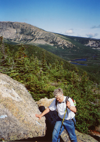
(NOTE: My 2004 images were shot on film and transferred to digital format via scanner or smartphone camera. Although several, including this one, do have focal issues, much of the blurriness you see is a result of the digitization.)
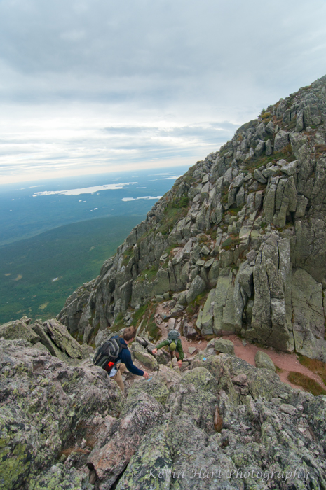
Sunday morning began for us at 3:45 AM so that we could arrive at the Roaring Brook Trailhead before it filled up. Our route that day would take us up the Helon Taylor Trail to Pamola Peak, across the Knife Edge to Baxter Peak, down the Saddle Trail to Chimney Pond, and the Chimney Pond Trail back to Roaring Brook. My Dad and I took off from the trailhead at 6:30 and embarked on what became my first memorable hike. In the beginning, the hike felt really familiar. As I wrote in 2004, the first mile or so of the Helon Taylor Trail reminded me of “any of our more challenging hikes from Pennsylvania,” but when we grabbed our first glimpse of Pamola Peak, it “struck us as much more serious than anything we’d hiked before.” The trail began to get more serious even before breaking treeline, though. When presented with large boulders in the trail, we’d have the choice to scramble over them or find an alternate route around them. I’d always opt to scramble over them, and I noted that Pennsylvania trails certainly didn’t offer this challenge to its hikers!
“As we neared the treeline,” I wrote in 2004, “we stopped at a rock for drinks, a small snack, and a chance to take in the remarkable view. I changed my film here, and got nervous as I felt the wind pick up. I began to wonder how bad the wind would be on the Knife Edge.” I’d like to note that the weather report we saw in Belfast was correct — it was very calm up there. It’s amusing now, looking back on my first big-mountain anxiety, knowing all that I’ve done since (such as the Knife Edge in 2013). But it is good to know that I’ve had a healthy dose of apprehension from the start; it may be why I’m still alive and mostly unhurt.

Dad takes in the first view of Pamola Peak, 2004. 
I stop at a rock near treeline.
Let’s pause here to take a look at the two images above. The one of the left was taken by me, whereas the image on the right was shot by my dad. As you can see, my dad’s shot has a much stronger composition, with the shape of my body forming a frame that leads the viewer’s eye into the scenery. Mine was a snap taken to remember our first glimpse of Pamola Peak, but there are no elements in the composition that lead your eye to the subject, and the person is not placed in a position that offers a sense of scale for the landscape. It’s disappointing in the sense that these are my physical memories of the hike, but they’re wonderful for providing contrast between where I started and where I ended up as a photographer. (I’m also not a huge fan of that light, but alas, only a fool would choose a stormy day for their first exposed hike.)
Continuing on, “the trees gradually turned to shrubbery, and… we arrived at the portion of the Helon Taylor Trail that we nicknamed the ‘big bad stuff’… Keep Ridge is actually just a bunch of boulders dropped on the mountain, where the real challenge is finding the best path through the boulders and then pulling yourself up over them. Exciting as it was, looking down was always a bad idea. At one point, I had to stop because my knees were shaking from a fear of heights I didn’t know I had.”
Below are some photos from this portion of the hike, but it was disappointing to discover that I didn’t have any shots that showed off the so-called “Big Bad Stuff.” Either I let fear and tiredness distract me from capturing photos, or I used a poor composition/perspective that failed to capture the severity of the terrain.

Right: My original caption states “where it looks like it drops off, it does” but a strong composition should do the talking for me.
Upon arriving at Pamola Peak, “we were both sore and tired, but Dad was especially worn. We ate lunch, and, after more than enough time to rejuvenate, we headed for the Knife Edge!” Even though the ascent to Pamola seemed to get the better of us, physically, I was totally hooked at this point. Life above treeline was the best. We had views in all directions, beautiful weather (can’t complain about a gentle breeze), and the exciting, unique Knife Edge taking off right in front of me. I was energized, enthused, and so in my element. Unlike my 56 y/o companion, probably, I was biting at the bit to continue our hike and my physical discomfort seemed to vanish in the breeze.


Even more memorable than our ascent on Keep Ridge was my first descent down into what is called The Chimney between Pamola and the Knife Edge. As I recalled in 2004: “The beginning section of the Knife Edge was my scariest adventure as a hiker to date. It was a small valley next to Chimney Peak where we climbed basically straight down and then straight back up. I let Dad lead the way down; my heart was pounding like mad. When we made it to the top of Chimney Peak, [fellow slow hiker] “Orange” told me ‘I saw you taking notes in there. You’re tough!’” Well, maybe. But while standing on the floor of the Chimney, I saw an older hiker with varicose veins bust up the side we had just come down in a fraction of the time. “Now *that’s* tough,” I had thought.
Next came the actual traverse of the Knife Edge. Dad told me I could go ahead, so I crossed it essentially as a solo hiker, stopping every now and then to at least let Dad get back into my line of sight. No breeze, no clouds, no worries. Several hikers traversing the opposite way stopped to congratulate me on a great job — I must have looked like a teen who had taken on Katahdin totally by himself. That’s a nice confidence booster for a kid whose lifelong relationship with the mountains was growing at that very moment. I arrived at Baxter Peak long before Dad and while waiting “another hiking party fed me candy… because Dad had all the food.” Not sure what made us divide up our supplies that way, but what a strange choice in retrospect.


I sit atop Chimney Peak, the wall we just descended behind me. 
Dad walks on the Knife Edge.


Top left was taken near Baxter Peak, Dad is in the jeans. At the time I liked this photo for the scale that it portrays, but I think the steepness of the terrain is lost in the perspective.
Top Right shows Pamola, Chimney Peak, and the Knife Edge (from Baxter), but the light is so flat I have a hard time appreciating this for anything other than documentary purposes.
Bottom: Knife Edge from Baxter Peak. This shot has an imperfect exposure, but is much better for showing depth and conveying the steepness of the terrain.
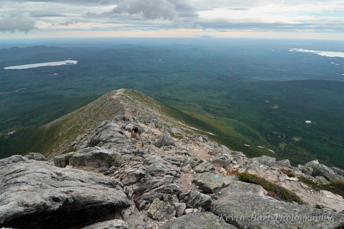
Dad eventually did arrive at the summit and was clearly in need of a rest. I didn’t take note of how long I spent up there, but I know that I didn’t mind a minute of it! First above-treeline experience or not, I felt totally comfortable at the top of world, and I took advantage of this time to chat with more experienced hikers, take in the incredible scenery around me, and soak up the perfect weather. (“Mom must be making sacrifices to Pamola [the God of the mountain],” Dad had said earlier.) When we finally took off, we cruised down through the Tablelands – a surprisingly flat boulder-strewn plateau opposite the Knife Edge – and began our descent on the mostly-stationary rockslide that is the Saddle Trail. We finally reentered treeline over an hour and a half after I arrived on Baxter Peak, putting us at a total of seven straight hours of exposure. (Even today, sixteen years later, that’s one of the longest blocks of time I’ve spent above treeline in a single day.) It took us another hour to arrive at Chimney Pond after dropping below the trees, thanks largely to what I assume was Dad’s full-body exhaustion and my lack of foresight in not breaking in my new boots.
We checked in at the Chimney Pond ranger station and they radioed Roaring Brook so that Mom could get confirmation that we had made it off the mountain safely. From there, we hiked the roughly three-mile Chimney Pond Trail back to Mom and our car. We had hoped that this trail would be an easy and quick three miles, but it wasn’t as flat as we had hoped, it was very rocky, and the sun set on us when we were only about halfway through it. I had noted that “in a different situation, this trail would have fascinated me,” but at the time we were going on 14 hours of hiking and just focused on making it back to the trailhead. I don’t even remember passing Basin Pond, even though I’m fairly sure we did so in daylight. Our hike officially ended at 8:25 PM and as Mom was driving us back to Neso Stream we all had our first moose sighting along the dark Tote Road.

Dad and I on top of Baxter Peak. 
The Basin from Baxter Peak.

The trail descends through the Tablelands. 
Dad sits in the shadow of the mountain on the Saddle Trail.
As I mentioned earlier, the days before and after our hike were rainy and foggy, and there was no resisting the moody conditions in the great northern woods. I’ve included some of my other images from 2004 below, before transitioning to 2013.


Bottom: From what I could find, this is the only photo I took at Daicey Pond (the rainy day after the hike) that didn’t have either of my parents in the frame (aside from a really blurry zoomed in attempt of a loon on the lake). The light was moody that day, the water calm, and Katahdin was partially visible beneath the clouds. Opportunities abound, but instead I took this photo of a dead tree on the water’s edge. I don’t like the composition, as it doesn’t lead to anything, but the biggest atrocity is the flash that I used to light the tree. Talk about removing depth from a photo. Nowadays, you’ll find me lugging a tripod to the most inconvenient places, all in the name of never using a flash.
Saturday September 7, 2013
Fast forward nine years to September of 2013. To set the scene, my (now) wife and I lived in St. Johnsbury, VT and I’d been out of college for 4 years. The past two-and-a-half summers I’d been working on the Vermont State Trail Crew, and the bearded 50-something-year-old Alex had been there with me, mentoring me in the ways of rock work and outdoor living. Alex had hiked the Appalachian Trail in its entirety twice in the 80s, has hiked every 4,000 footer (and many of the trail-less 3,000 footers) in New York and New England, and has a plethora of other outdoor experiences. He has no shortage of fantastic stories revolving around places I’d come to love. During my third year on crew I decided I wanted to revisit Baxter with Alex and Galen, the youngin’ on crew that year. We decided (well past the open window for making reservations at Roaring Brook) on a weekend in early September and planned on snagging one of the first-come first-served sites outside of the park gates.
That Friday, Alex and Galen drove to our apartment in St. Johnsbury, the closest point between the three of us to Maine. Piling into my Subaru, I drove the three of us up to Baxter in a much more efficient fashion than nine years prior — with no stops, we made it in about 6 hours. Alex directed us to the Abol Bridge section of the Golden Road, which we arrived at only a few minutes before sunset. We passed a swamp with a bunch of young saplings in it, all donning peak red foliage lit up by the dynamic last rays of the day’s light. There was a photographer set up there and I was tempted to stop, but Alex reminded me that we were in a rush to claim a spot before others did. As we passed over the Abol Bridge, we had a clear view of Mt. Katahdin with a large, sunset-lit cloud hovering over it. Galen named this cloud, which looked like it had the singular purpose of abducting the mountain, “The Mothership.” Again, I passed up a dramatic photo opportunity in favor of finding a place to camp. We claimed a spot with plenty of space for three tents right along the Penobscot River, and after dropping off Alex I sped back to the Abol Bridge only to find the dramatic light had vanished.
The following day was Katahdin day. Galen and I planned to follow the same route I had done with Dad, while Alex decided he wanted to claim the only trail on the mountain he had not yet hiked — the Dudley Trail. As I write this seven years later, I don’t remember my reasoning for sticking with the Helon Taylor up, Saddle down route, except for my desire to experience the Knife Edge again (and, of course, to let Galen experience it for the first time). I was drawn to both the Cathedral Trail and the Dudley Trail, the former of which is the park’s most technical route and the latter the steepest. It’s very likely that I didn’t want to do the Chimney Pond Trail twice (Cathedral and Dudley both take off from Chimney Pond and our starting point was Roaring Brook), and it’s possible I wanted to retrace my steps with my improved camera skills specifically in mind. I remember considering at one point descending via Cathedral instead of Saddle, but the park strongly discourages that.
Whatever our reasoning, we left our campsite around 8 and made it to the Roaring Brook parking lot as it was starting to fill up. Galen and I took off first and headed for the Helon Taylor Trail. Alex had a more relaxed timeline, as he was planning to ascend via Helon Taylor and descend Dudley, summiting only Pamola that day. Per the ranger’s suggestion, he adjusted his plan to ascend Dudley, and took off on the Chimney Pond Trail shortly after we left.

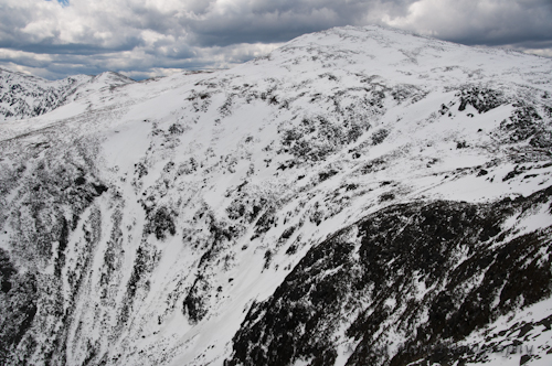
We ascended the Helon Taylor Trail under overcast skies this time, at a much quicker pace than before. Galen and I were both fit hikers (I was actually the slow one here), and we were really only stopping for the photo opportunities I’d see. Galen’s a great sport, and when I asked him to go off trail and climb a boulder for perspective, he agreed and seemed happy to put in this extra work for my creative vision. As we made our way above treeline the wind really started to show its fierceness, and made I an effort to capture its power in my photos. Keep Ridge ascended the leeward side of Pamola Peak that day so we were (somewhat) sheltered and weren’t yet feeling its full effect, but it was strong enough to create a memorable and more exciting ascent than 2004’s.


Top Left: The scenery from the Helon Taylor Trail under a dramatic sky, sans Galen.
Top Right: Helon Taylor Trail. Overall, this is a bit dark and the shadows could probably benefit from some fill light, but I loved how the darker exposure brought out the texture in the sky!
Bottom Left: My first glimpse of the Knife Edge since 2004! Processed to highlight the drama of the weather and terrain.
Bottom Right: A wider shot from the same vantage as the previous photo. My intention here with both the composition and processing was to show the nature of the trail. In the foreground, we see it cut through the alpine shrubbery, and in the background, climb the final ascent to Pamola Peak and the castle-like Knife Edge.


Top Left: The alpine grasses blowing in the increasingly strong wind. The diffused light from the cloudy sky is perfect for retaining the colors of a landscape.
Top Middle: I was drawn to this scene because of the lines leading out from the rock, but I think its strength actually lies in how it appears to capture motion in the sky. Landscape images, devoid of people, can (and should) also tell a story.
Top Right: Bracing against the wind, Galen scales a typical section of trail on Keep Ridge. I used a low perspective to enhance the drama of the terrain, as well as a technique called “tonemapping” to bring detail to the shadows.
Bottom Row: Galen ascends what I referred to in 2004 as “the big bad stuff” on Keep Ridge. By 2013, I was an experienced enough photographer that I had started to use the medium for artistic outputs in addition to documentary ones. As such, I began to make creative decisions that featured emotions over sheer documentation. The last photo is an example of that, as I left it intentionally dark to feature the mood of the brooding, stormy weather.
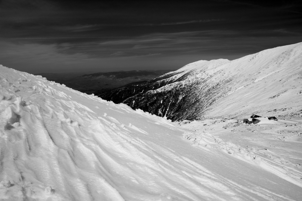
Upon arriving on Pamola Peak, the wind hit us full tilt. It was easily strong enough to knock us over if we didn’t plant our feet against the rocks and lean into it to brace ourselves. Given this, we estimated the wind we were feeling fell between 40 and 60 miles per hour, and it was indescribably exciting to witness. As far as my photographic instincts were concerned, this was the pinnacle of our hike. The wind was blowing clouds in and out all around us, and was drastically changing the scene every few seconds. It was exhilarating and chaotic all at the same time!
We were up there for a good long while. Not only was I snapping constantly to try and capture the ever-changing drama, but we began to reconsider the wisdom of crossing the Knife Edge. I had remembered from 2004 that there were three short sections on that ridge (I refer to them as the “bridges”) that were particularly narrow, flanked on either side by… nothing. The wind was blowing perpendicularly to our direction of travel. Was it safe? Well, it wasn’t raining, and I felt that if it stayed that way, we could maintain solid traction on the rocks. By spending so much time up on top of Pamola, we could gauge the weather’s trend and determine if the likeliness of rain was increasing or decreasing.
While we were hanging out on that windswept summit, a couple hikers joined us. One group of three guys (one of whom – wearing a green jacket – was a dad to at least one of the boys) followed us up from the Helon Taylor Trail. The two boys decided they definitely didn’t want to attempt the Knife Edge in the wind, but the dad, who I believe had done it before, wanted to experience it again. He told his boys that he was coming back, dropped down into the Chimney and climbed up the other side, and disappeared for a while. Galen decided that he at least wanted to experience the Chimney if we ended up forgoing the Knife Edge, so he followed the dad down the Chimney and up to Chimney Peak, where he stopped and donned his orange “goon” hat. Since he was in my line of sight the whole time, I was comfortable with that. And I mean, really, who am I to say no to some extra photo ops at Galen’s expense? As he came back and was ascending Pamola again, I got some fun photos of the wind ripping over him.
After the party of three took off again down the Helon Taylor, one hiker (wearing a blue jacket and bleeding from his forehead) joined us from the Dudley Trail. (We learned the following morning that this was the quickest hiker in the party that Alex had tagged along with.) He took our photo at the Pamola summit and shortly after that we noticed that the blue sky in and out above the Knife Edge seemed to be getting more prominent. We took this as a sign that the weather wasn’t deteriorating and, even though the wind wasn’t letting up, we left Pamola, descended into the Chimney, and took off onto the Knife Edge. (It turns out, Alex wasn’t far from the Pamola summit at that point and we almost shared it with him, but ended up never seeing him.)


Middle: Galen shoots a photo while in the “wind stance.”
Right: The ever-changing landscape presented many opportunities to capture a sense of depth. Here, a cairn on Pamola leads the eye onto the Knife Edge and the chaos that lies therein.


As I descended into the Chimney I noticed that it acted as an incredibly fierce wind tunnel, possibly the fiercest I’ve experienced. I have no idea how much it may have magnified the effect of the wind, but crossing the floor of the Chimney was super exciting and magnificently chaotic. There’s a boulder sitting on the Chimney floor that I ducked behind for relief and would pop up from for the briefest moments to try to capture the view. This was a poor comparison, but at the time it was chaotic enough to feel like a soldier in wartime. I took some shots while shouting at Galen how crazy this was, and then we climbed up the opposite side. The ascent up to Chimney Peak follows a route on the leeward side of the wall, so it felt tame in comparison to what we’d just done.


Middle: Galen ascends the leeward side of Chimney Peak from the Chimney.
Right: From the leeward side of Chimney Peak, looking back at Pamola and the wall we’d just descended.
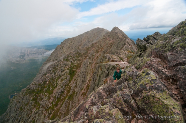
Galen did the Chimney three whole times that day, but despite how intense that is he really didn’t show any signs of fatigue. Once we were on Chimney Peak, the wind was gusting from the side, as we expected, and we didn’t have a view, so we just boogied onward. We were in and out of a view for the first bit of the Knife Edge, and we’d pause here and there for photos or to duck behind a wall if one were available. I had both my tripod and camera on this hike (although that lighter-grade tripod would’ve been useless in that wind), and I was keeping them outside of my pack. (The camera bag was hanging free by my hip.) Generally, that’s not a great inconvenience to me, but I could feel them catching in the wind as we traversed the exposed ridge. My camera, especially, was quite the inconvenience as I crawled my way along the “bridges.” Each of these bridges was a four-limbed nerve-wracking experience, and I had to concentrate on gripping both the rocks and my camera bag so as not to blow over or trip on the straps. Despite this, all three felt a little easier than I had anticipated.
After the third and final bridge, Galen and I were resting in an exposed spot and one of only three or four hiking parties passed us going the opposite way. We watched as one female hiker had a meltdown at the start of the bridge, while her significant other patiently and heroically coached her across. We couldn’t fault her for the breakdown — as I’ve said several times, high winds make things feel chaotic. High wind in tame terrain can cause stress by itself, as can these Knife Edge bridges in calm weather. Combined, its easy to feel an abundance of stress and fall into the mental trap of believing that the terrain isn’t passable. Fortunately, nothing like that happened to me or Galen up there, but I would feel an overwhelming stress on a mountain the following year. Once the feeling of helplessness and “what am I doing here” sets in, it’s hard to shake. Kudos to that hiker for overcoming her fear and getting across the bridge. That struggle only made her stronger. In my experience, every time I put myself outside of my comfort zone on a hike, the better I’m able to handle the stress of the next unusual situation. It’s like mental gymnastics.
Galen and I continued, by now mostly enshrouded in total fog. We came across a husband and wife hiking party at some point and I felt compelled to ask them a question that I hate. “So uh.. it’s been a while since I’ve been up here and I can’t… how are, uh, how far back there did you.. uh, we getting close to Baxter?” I don’t like when people ask “how much further” in any form. But I’m so, so glad I chose to engage this Mainer, for he gave me the only response a Mainer could: “Ayuh, you’re gettin’ they-uh!”
Sure enough, there we were getting and it was maybe ten minutes later that we stepped onto the fully socked-in Baxter Peak. We didn’t spend long up there, but as we were heading down into the Tablelands this somewhat neurotic lady with a Minnesotan accent named Trish came up to us and was impressed to hear we had crossed the Knife Edge. She immediately told us that her friend Pam had been really struggling up the Saddle Trail and she was wondering if we could stick around until they tagged the summit. Yeah, why not? She hung out with us while waiting for (and worrying about) Pam, and I mentioned how bummed I was that the sun didn’t start breaking out for us by the time we reached Baxter.
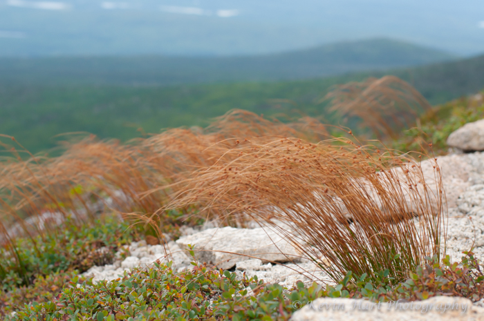
As Pam came huffing up the Saddle Trail (she was out of breath, but hardly in as dire a state as we expected), Trish left us to tag Baxter with her friend. As we promised, we waited for Pam and Trish in the Tablelands, and I really didn’t mind at all. The Tablelands are a beautiful and unique feature for such a mountain, and I stayed fully entertained photographing the blowing grass and capturing depth through the fog. Before long, Trish and Pam returned to our location and the sun started to break through. Trish started cheering for the sun and absolutely lost her mind when the clouds broke and revealed the full landscape around us. She was ecstatic for me! She insisted on taking our photo next to the cairn where we were, and we accompanied the two of them to the top of landslide that the Saddle Trail descends. Trish had asked us to accompany them only this far, but before we took off I asked her if she was sure. After all, descending the slide is considerably trickier than ascending it or walking through the Tablelands. Trish, though, was insistent that she didn’t want to hold us up any longer (and Pam never really wanted our help in the first place), so Galen and I took off down the Saddle.
When we got to Chimney Pond, we swung by the ranger station briefly to report that we were off the mountain and that we were pretty sure we were experiencing winds around 50mph. He replied that he had absolutely no doubt that this was the case, and implied that we might’ve even underestimated it. (I have no doubt that the windspeed was considerably stronger in the Chimney.) I guess we’ll never know for sure, but I absolutely know that this was, and continues to be, one of my favorite hikes ever. We were motivated to get the Chimney Pond Trail done as quickly as possible and busted it out, again bypassing Basin Pond in favor of a timely return to Roaring Brook. We arrived back at the trailhead before dark (for a total hiking time of around 10 hours) and were happy to hear we’d only been keeping Alex waiting for less than two hours.


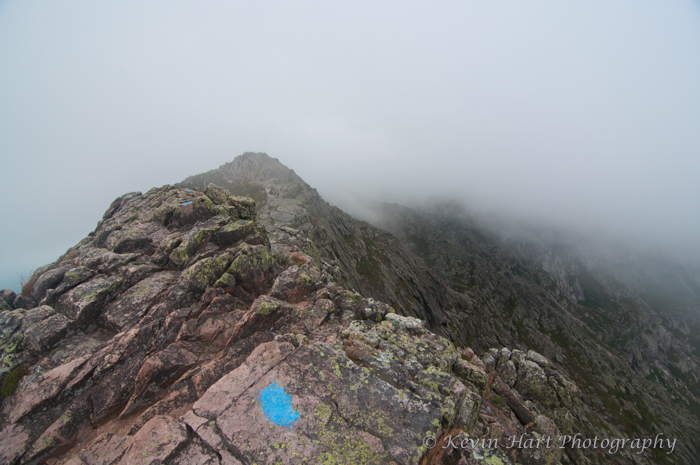


Top Right: Blue blazes lead the way into the void.
Bottom Left: Looking across a bridge back towards Pamola Peak.
Bottom Right: A very dramatic shot of the wind pushing a cloud through the Chimney. One of the last clear views we got until the Tablelands.


Top Left: Looking down on Chimney Pond and the cliffs above it. The post-storm lighting here makes all the difference, and helps counter the compression that results from using a long focal length.
Top Right: Telephoto shot of the Chimney. Again, the post-storm light is critical to the composition.
Bottom Left: Wider perspective showing the Dudley Trail, Pamola Peak, the Chimney, and the first bit of the Knife Edge.
Bottom Right: Looking down the Basin towards Chimney Pond. The Dudley Trail follows the furthest ridge on the right.


Left: A drainage found along the Chimney Pond Trail.
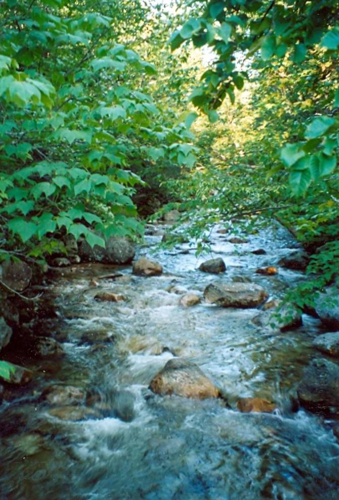
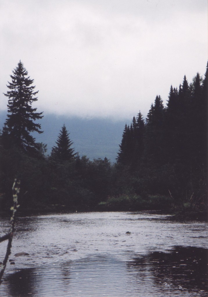
Middle: Roaring Brook after our hike.
Right: The Penobscot River next to our campsite.


Saturday September 23 – Sunday September 24, 2017
On my third visit to Baxter State Park, Galen and I returned with another trail crew friend Kyle. My goals were to photograph Green Falls (a beautiful and remote waterfall that flows into Lake Wassataquoik in the vast wilderness north of Mt. Katahdin) and to bag the Cathedral Trail. Alex had talked up the Dudley Trail after our 2013 trip and I had developed a great interest in it, but in 2016 a massive landslide had knocked out that trail and it had yet to be rerouted.
(Even as I write this in 2020, the Dudley Trail has yet to be reopened. Crews are working to reroute it, but “the terrain is very challenging.” Well yeah, I don’t even know where they’d put it! I’m just glad to know that reopening the Dudley Trail is apparently a goal of the park.)
Despite my love for mountains and treeless alpine zones, waterfalls had become my priority as a photographer for most of the decade. When I learned of the beautiful Green Falls that was barely visited thanks to its remoteness, I decided I had to make it happen. We agreed on a weekend in September and I reserved a lean-to in Roaring Brook for three nights. Cathedral Trail + Knife Edge one day, Green Falls the other (planning for the nicer of the two days for Katahdin).
That wasn’t how it was meant to be, though. During a trail project three weeks prior to our trip, I blew out my right shoulder and lost my range of motion for a month or so. Feeling that I could still support a backpack we decided to carry out our plan, but I knew I shouldn’t do the Cathedral Trail with all of the overhead reaching that it’d require. Instead, we’d split up, Galen and Kyle doing the mountain via Cathedral (Kyle’s first and only time on Katahdin), and I’d do a solo adventure to Green Falls.
After a somewhat lazy morning, Kyle and Galen took off down the Chimney Pond Trail while I forked north and headed up towards Russell Pond. It was a warm, beautiful September day and there was no shortage of campers in Roaring Brook or hikers sharing the trails with Kyle and Galen. But once I branched off to head to Russell Pond, I had the trail to myself.
My first stop that morning was at Whidden Ponds, where I was treated to a fine view of Mt. Katahdin in morning light (but well past the golden hour). From this perspective, about half of the Knife Edge was obscured by Pamola, but it nonetheless ranked up as perhaps the best view of Mt. Katahdin I’d seen across my three visits to Baxter.


Continuing on, as I sauntered through the quiet forest on the mostly flat and sometimes muddy trail, I began to hear some leaves rustling and a couple subtle “moo” sounds. Naturally, I looked to my left, and not even 50 feet off the trail were a bull moose and his two cows. Their conversation promptly stopped as the bull gave me his full attention. My camera was around my neck and very easy to access (I had been trying to capture what slight signs of autumn I could find) but I didn’t want the action of raising my camera to my face possibly taken as a sign of aggression. So I kept walking, the bull’s gaze following me every step of the way. I couldn’t help but feel defeated as I left the moose’s line of sight — I had given up one of the most unique photo opportunites I’d ever been presented with. But I don’t really trust moose, especially male ones that have mating on their minds.
When presented with a choice between staying on the Russell Pond Trail (more direct, but over a hill) or merging onto the Wassataquoik Stream Trail (flatter but longer), I chose to stay on the Russell Pond Trail. Before long, I was hiking into the Russell Pond camping area, where I swung by the ranger station to tell him about the moose and find out if I made the right call. (Essentially, yes. Moose are unpredictable but it wasn’t yet rutting season and he was likely pretty docile.)
I continued my solo journey onto the Wassataquoik Lake Trail, a wild and remote trail that passed a few beautiful ponds with a canoe or two stashed near them. As the trail weaved in and out among the ponds and the quiet forest, I had never felt further removed from civilization. One other small hiking party passed me as I was approaching the big lake, and I saw nobody else until I was back at Roaring Brook. I was having a great time in pretty much total seclusion, and it occurred to me that this was likely the furthest north I had ever hiked. I also realized that Kyle and Galen were likely having a dramatically different day up on the mountain.
As I came upon Wassataquoik Lake, I discovered a small rack of canoes which are used, I assume, to access the campsite on the island. I also startled a flock of mergansers, who then made their way swimming and diving over to the opposite shore. These were the first mergansers I had ever seen, and I thought at first I was seeing loons. However, while mergansers can also swim under water, they were spending considerably less time under water than loons would’ve and they seemed a little too active. I would later learn that their name is derived from the Latin word for “plunging goose.”
From here I had to hike about halfway the length of Wassataquoik Lake (which was longer than I expected) to get to Green Falls. I far prefer overcast days to sunny ones when it comes to shooting waterfalls, and yet here I was putting in an intense amount of effort to reach this remote waterfall on a cloudless day. Would it be soaked in sunlight? I (foolishly) hadn’t thought to check the aspect of this creek before heading out, but fortunately it was northeast and I was grateful to find it in the shadow of Wassataquoik Mountain. As I came across this delightfully unique waterfall, I forgot all about my hunger and tiredness and instead set my mind to photography and scampered about the rocks to find the best perspective.


I must’ve spent the better part of an hour at this remote waterfall, trying to capture its unique beauty, enjoying true solitude, and eating lunch. On my way out I hiked down to the shore of Wassataquoik Lake to take in the view from the stony beach at the canoeists’ access to Green Falls. Again, I was impressed by what I was seeing: the mountains that flank the lake are (smaller than Katahdin, but) adorned with large cliffs and slopes of scree. It occurred to me that if Alex is interested in camping with me here in the future (and why wouldn’t he, he loves canoe camping), we’d have lots of cool things to explore, on and off trail.
I made my way back to Russell Pond, keeping my eyes open for photo opportunities that spoke “autumn.” Aside from a growth of mushrooms, which I enjoy shooting for their unique textures and colors, I didn’t have much success. Beyond Russell Pond, I decided to make my hike more interesting by branching onto the Wassataquoik Stream Trail, although I admit that my thought process at the time may have been more geared towards the promise of flatter terrain than additional scenery. I’m happy with the decision. It led me to a (bridged) creek crossing with a fairly strong essence of autumn, and then an unexpected surprise in the form of a ford that was almost deep enough to submerge my waist. I had to hike the last few miles with squishy socks, but hey, that’s just an added bonus of hiking in a wilderness setting. Although nothing close to peak color, I finally captured some pleasant fall reflections in the moving water at both of these spots.


Left: A 1/4 second exposure (not long, but also not fast) of Wassataquoik Stream at the bridged crossing.
Middle: Unprocessed image of the view that greeted me after fording Wassataquoik Stream. The light was beginning to improve for me at this point, but this was just about the last place I could appreciate it — the rest of the my hike was essentially in shadow.
Right: One last sign of autumn on the forest floor. Found this tiny stream flowing over the Wassataquoik Stream Trail under one of the park’s few trees in foliage.
I returned to the Roaring Brook campground after a total of 22 miles, and this turned out to be one of my highest-mileage single days on foot. I returned just as the dark was setting in, and to no surprise, several hours after Kyle and Galen. All three of us were tired and in retrospect questioned the original plan of taking on these two hikes one day right after another. We decided to cut our three-night visit down to only two, and we would take off the following morning.
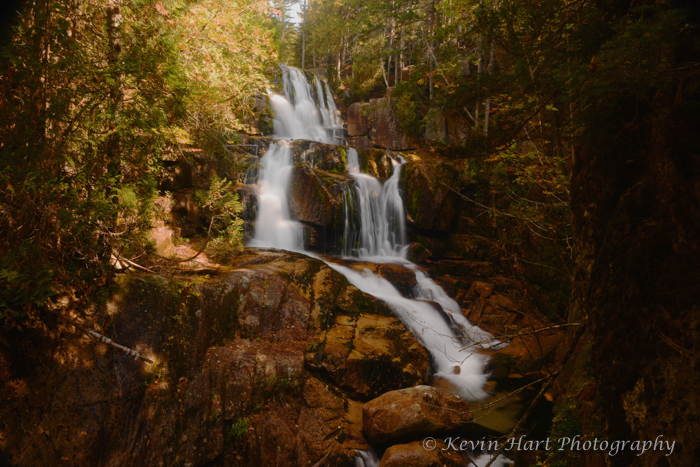
The next day, after we packed all of our stuff back into the car, I asked if Kyle and Galen would be interested in visiting one more waterfall before we left. They were open to it, so we drove to the Hunt Trailhead and managed to squeeze into a parking space. It was another warm, cloudless day and the hikers were heading up the mountain in droves. We were only heading 1.2 miles up though, to Baxter’s most popular waterfall, Katahdin Stream Falls.
This triple-tiered waterfall was more open to the sun than Green Falls was, and it made photography difficult. Nevertheless, I explored three different vantages. First, I shot from the overlook in the middle, which is right off the trail and provides a full, but partially branch-obscured view of all three tiers. I shot right from the edge of the bank to minimize branch interference. Second, we found a small herd path leading down to the cliffs and pools below the falls, and walked up the creek a bit for a nice perspective of the lower tiers. Lastly, we followed the trail up for close-up views of the top tier, which is easily the most unique. When I was done here, we hiked out and headed home.

Right: An HDR-blended photo from the base of Katahdin Stream Falls after boulder-hopping up the stream a bit. I love the composition from down here, but the light proved very tricky. I blended three exposures together to compensate for the strong highlights, but the result is still busier than I really like. Just have to go back on a cloudy day. You can see a hiker in red at the top.

Conclusion
If anything is clear to me after retelling the stories of all my visits to Baxter, it’s that Baxter State Park has played a critical role in my life story. The first trip in 2004, in particular, made a heavy impact on the person I became. I went up as a mostly inexperienced hiker/car camper with a point and shoot camera and limited knowledge of the art of photography. I came back the same way, but with three important developments:
- My unimpressive tour of Unity College led me straight to Green Mountain College in Vermont, where I earned my degree and met my wife.
- I discovered a passion for landscape photography. Although my images from 2004 are largely unimpressive, my excitement over those images ignited a spark that led me to develop what became a very serious hobby and eventually a business.
- I experienced a treeless alpine zone for the first time, and fell in love with it. This no doubt influenced my decision to join the Vermont State Trail Crew after college and begin to tackle the northeast’s 4,000-foot peaks.
When I returned after nine years, I was a very experienced hiker and backpacker thanks mostly to my years on various trail crews. I was also the owner of a camera that allowed me to take control of my creative process — a digital SLR — and had just recently begun selling my photos. Although the type of person I was becoming was already plenty evident (an outdoors lover with a propensity for taking photographs in sketchy places), this second trip has also played a role in shaping me:
- I expanded my comfort zone with uncomfortable situations and conditions. Having a tolerance for such things is critically important in both trail work and (my approach to) waterfall photography. As I mentioned in the 2013 Knife Edge recounting, the “mental gymnastics” that you take on when leaving your comfort zone do wonders for that tolerance.
- I grew to further appreciate “nasty” weather for memorable photo opportunities.
- I saw myself practicing sound decision making in a chaotic environment.
Above all, this project demonstrated that my photographic skills have improved, and continue to improve, considerably from where I started. The nine years between 2004 and 2013 saw significant leaps in both my technical ability and my creative vision, and it’s immensely obvious. But despite how awesome and inimitable the conditions were in 2013, I’m most excited about my growth between 2013 and 2017. Take a look at my photos of Green Falls. My precise control over my shutter speed, focal point, depth, and color demonstrate that my technical ability was continuing to improve. But most importantly, I had also been continuing to define my creative vision, which is what truly makes me an artist. My vision, not my technical prowess, is my voice, and is defined by all the things that make me me: my experiences, my biases, my emotions. While I am greatly excited by my 2013 fog photos, I am most proud of the images from 2017 that I can distinctly call “mine.”
These were exciting trips to rediscover, and I thank you for taking this journey with me.